Bald Head Island History
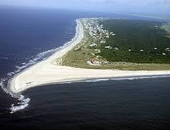
Bald Head is a barrier island located at the mouth of the Cape Fear River and is home to one of North Carolina's three capes: Cape Fear. Sir Richard Grenville likely named the cape during his 1585 expedition, prior to founding the famous Roanoke Island colony. Grenville feared a submerged sandbar, known due to its shape as Frying Pan Shoals. The shoals extend nearly thirty miles from Cape Fear into the Atlantic Ocean.
In 1662, William Hilton led an expedition up the Cape Fear River, mapping Bald Head Island and leaving livestock on the shore. This paved the way for permanent settlement in the region, culminating in the establishment of Brunswick Town in 1726.
Today, Bald Head Island is known for its stunning natural beauty, pristine beaches, and rich history.

.png)
_JPG.jpg)
